Details
| Status | For Lease |
|---|
Demographics
| Demographic | 1 Mile | 3 Miles | 5 Miles |
|---|---|---|---|
| Population | 7,395 | 44,199 | 110,030 |
| Daytime Employees | 2,377 | 24,000 | 56,605 |
| Households | 2,820 | 18,457 | 45,269 |
| Average Household Income | $178,302 | $127,407 | $110,217 |
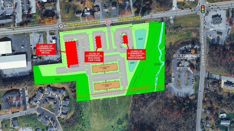
| Traffic Count | Linglestown Road - 13,860 A.D.T. | ||
| Traffic Count | Colonial Lane - 10,066 A.D.T. | ||
Description
About Harrisburg
The Harrisburg metropolitan area extends well beyond the city limits into a network of thriving suburban corridors, with Linglestown Road serving as one of the region’s most commercially active arteries. Running east from the city into Lower Paxton Township, Linglestown Road functions as a primary connector between established residential communities and the region’s major highway infrastructure. The road feeds directly into Interstate 81, one of the East Coast’s most significant freight and commuter corridors, linking the Harrisburg area to markets stretching from Tennessee to New York. This connectivity has made the Linglestown Road corridor a magnet for retail, healthcare, and service-oriented commercial development over the past several decades.
The combination of strong rooftop density, high average household incomes, and easy interstate access makes this stretch particularly attractive to retailers, medical operators, and developers looking for suburban infill opportunities with proven consumer demand and longterm stability.
Highlights
Two Proposed 4-Story Apartment Buildings with a total of 88 Units
High Visibility Along Linglestown Road (Route 39) with 13,860 AADT and Near Signalized Intersection
Minutes from Downtown Harrisburg, the capital city of Pennsylvania
Situated Near a Major Interstate Retail Corridor with Strong Household Incomes of $178,302 within a 1-Mile Radius
Contact